Google today announced that Google Maps is getting support for 39 additional languages. The newly supported languages are Afrikaans, Albanian, Amharic, Armenian, Azerbaijani, Bosnian, Burmese, Croatian, Czech, Danish, Estonian, Filipino, Finnish, Georgian, Hebrew, Icelandic, Indonesian, Kazakh, Khmer, Kyrgyz, Lao, Latvian, Lithuanian, Macedonian, Malay, Mongolian, Norwegian, Persian, Romanian, Serbian, Slovak, Slovenian, Swahili, Swedish, Turkish, Ukrainian, Uzbek, […]
View More Google Maps gets support for 39 new languagesCategory: Google-Maps
Google Maps launches a ‘wheelchair accessible’ option for 6 cities
/https%3A%2F%2Fblueprint-api-production.s3.amazonaws.com%2Fuploads%2Fcard%2Fimage%2F735327%2F732a005d-36c2-4df1-bd37-0c3ed043a450.jpg)


Big cities like London usually aren’t known for being easily accessible to people using wheelchairs, but a new feature from Google Maps is a step toward making it easier.
Google Maps on Thursday launched a “wheelchair-accessible” option for six major cities.
“In city centers, buses and trains are often the best way to get around, which presents a challenge for people who use wheelchairs or with other mobility needs,” said Google in a blog announcement. “Information about which stations and routes are wheelchair friendly isn’t always readily available or easy to find.” Read more…
More about Google Maps, Wheelchair Access, Social Good, Transportation, and Web Culture
Google adds a wheelchair-accessible option for transit maps
Google Maps has a pretty solid set of data for taking transit from here to there, but anyone with a physical disability knows it isn’t quite that simple. Some stations may be wheelchair-unfriendly, have out-of-service elevators, that kind of thing. A new update to the service adds an option for you to specify a wheelchair-accessible route — though that’s just a start on what’s really needed.
View More Google adds a wheelchair-accessible option for transit mapsGame developers can now use Google Maps to build the next ‘Pokémon Go’
Google wants to help developers build the next Pokémon Go.
The company announced that it’s opening Google Maps to game developers who want to use its data to build location-based games similar to Pokémon Go.
SEE ALSO: Google Maps has a ‘Mar…
Google is using Maps to turn every video game into an earth-sized epic
Video games are about to look a lot more like the real world. If you’ve enjoyed the thrill of driving through GTA V and spying out Los Angeles landmarks, then that’s a sentiment you’re probably going to start feeling a lot more often while you play video games. Google is making its Maps API play nice […]
Who’s a very good Street View camera? You are!
 For its latest addition to Street View, Google has employed a trio of very good (and extremely fuzzy) boys — Ako, Asuka and Puuko. In order to capture the snowy streets of Ōdate City, Japan, the company strapped 360 cameras to the backs of the three Akita dogs, which hail from the country’s cold and mountainous regions. The company can’t seem to decide between Dog View or… Read More
Google Maps has a ‘Mario Time’ feature, and it’s as awesome as it sounds
Google might have outdone itself with the best Google Maps easter egg yet.
The latest version of the app includes a new ‘Mario Time’ feature that allows the classic Nintendo character to drive along with you on your route.
SEE ALSO: Shaun White’s Win…
Mario can now guide your route in Google Maps
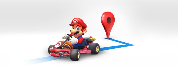 It’s Mario Time! Beloved gaming character Mario is coming to Google Maps, thanks to a partnership between Google and Nintendo ahead of Mario Day, March 10. (MAR10…get it, Mario?) In addition to the various deals and sales on Nintendo games, the mustachioed plumber will also make an appearance in Google Maps’ navigation, if you opt in to have Mario accompany you on your… Read More
Mapbox makes another acquisition to bolster its navigation toolkits
 Mapbox, the Softbank-backed developer of mapping applications that competes with Google Maps TomTom and Here, has acquired the intellectual property and developers behind MapZen’s Valhalla project in a bid to strengthen its navigation toolkits. The acquisition, made as Mapzen was winding down, brings the Valhalla development team in-house for a bargain price that Mapbox chief executive… Read More
You’ll never get lost in an airport again with Apple Maps’ indoor mapping
Every editorial product is independently selected by Mashable journalists. If you buy something featured, we may earn an affiliate commission which helps support our journalism.
Raise your hand if you remember what a joke Apple Maps was when it launc…
Google Maps will soon tell you when it’s time to get off your train or bus
Google is about to launch a small but useful update to Google Maps that will give you live guidance and interactive real-time notifications during your journey. The idea here is to give you real-time updates while you are on your transit journey….
View More Google Maps will soon tell you when it’s time to get off your train or busLAPD warns that navigation apps are steering people to neighborhoods on fire
/https%3A%2F%2Fblueprint-api-production.s3.amazonaws.com%2Fuploads%2Fcard%2Fimage%2F670417%2F343f7e5a-32f9-4722-a4d4-6cbf4c7071cc.jpg)
There are currently multiple fires raging across Southern California, one of which forced the notoriously clogged 405 Freeway in Los Angeles to shut down.
Big fires force people to find new routes — including people using apps like Waze and Google Maps.
The problem? Those apps look for roads without many cars on them, and try to route you there. Which is great when you’re trying to avoid run-of-the-mill traffic. But not when the roads are clear because of nearby fires.
“The Los Angeles Police Department asked drivers to avoid navigation apps, which are steering users onto more open routes — in this case, streets in the neighborhoods that are on fire,” the Los Angeles Times reported. Read more…
More about Los Angeles, Google Maps, Wildfire, Wildfires, and Waze
View More LAPD warns that navigation apps are steering people to neighborhoods on fire